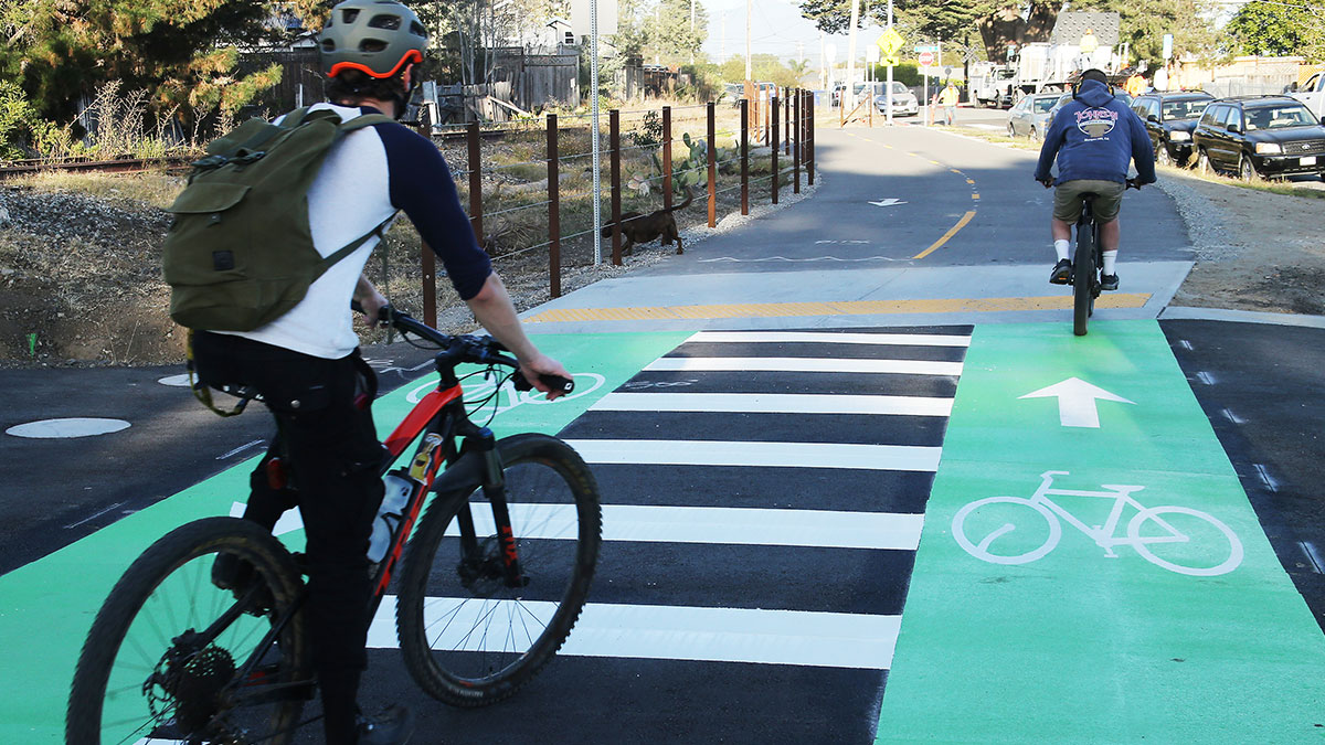
A segment of the Coastal Rail Trail, a planned bike/pedestrian path that could one day connect Watsonville to Davenport, officially opened last week.
Due to the Covid-19 pandemic, the Dec. 10 ribbon-cutting for the rail trail Segment 7/Phase 1 was streamed online.
This new 1.2-mile section of asphalt trail, which is 12- to 16-feet wide, runs from Natural Bridges Drive to Bay Street and California Street on Santa Cruz’s Westside. Graniterock built the trail segment, which features 10 bright green bicycle crossings, several new pedestrian crosswalks, signage, and new fencing. One goal of the trail is to provide a safe connection between schools, activity centers, parks and businesses.
“This is my very first day to walk on the trail,” said Sara Walsh, who lives nearby, as she strolled Segment 7. “I love it. I try to do walks two times a day, so this will be perfect because this area is in my regular loop. It feels safe, and I think it will make the neighborhood feel more comfortable.”
The Santa Cruz County Regional Transportation Commission (RTC) has been handling high-level planning for the trail, which is part of the Monterey Bay Sanctuary Scenic Trail Network. For years, the RTC has been studying the possibility of introducing transit, like a commuter train, alongside the trail, an idea that’s been met with mixed reception over its feasibility, projected ridership and its possible costs.
The rail trail project is divided into 20 segments—one and a half of which have now been built. The city of Santa Cruz is wrapping up the design phase of the second phase of Segment 7.
The first completed section of rail trail, Segment 9, includes the bike lane outside the Santa Cruz Beach Boardwalk and an extension of a bridge over the San Lorenzo River that opened in January of 2019.
At the ribbon-cutting, Santa Cruz County Supervisor Ryan Coonerty, an RTC commissioner, praised the $9 million Westside trail project.
“It’s an incredible way to get across town,” he said. “Soon we will have a 32-mile bike and pedestrian path across Santa Cruz County.”
The new section of trail called for 600 tons of asphalt, mostly made up of asphalt grinding from recent road projects.
Kevin Winch, who’s lived near the adjoining railroad tracks for the past 20 years, welcomed the addition as he toured it by bike.
“Yes, I will definitely use it,” he said. “I used to ride along the tracks on the dirt all the time so this is nice; I like it. Graniterock did a nice job. As you can see, it’s certainly getting used.”
After cutting the ribbon, Mayor Cummings ran through a long list of thank yous for making the project happen, including for the RTC, Pacific Crest Engineering of Watsonville, former Congressmember Sam Farr, county supervisors, the Coastal Conservancy, Ecology Action, and Bike Santa Cruz County.
The trail is designed to welcome people with disabilities, walkers, bikers, and parents with small children.
In South County, work is moving ahead on the south section of the trail off of Ohlone Parkway in Watsonville. There the trail will tie into the more than six miles of slough trails.


This was four times the estimated cost for 1.3 miles section, 6.4 million dollars. Poor design, poor execution, unsafe for more than two cyclists at a time. Have to negotiate curbs and signage in pathway. Cyclists can get caught up in dangerous fencing. Come on RTC! You can and you must do better. Otherwise, we’ll have a useless 32 Mile Run that no one can use.
A 75 foot wide corridor yet less than 20% of it was used for a path, and that part was shoved to the side and fenced with no runoff area. We can do better than this.
Great work! I’m jealous that Santa Monica and all those So Cal beaches have a some 20+mile coastal trail and Nor Cal sort of does not. News flash, it costs good money to pay good Americans to build great things. Boo hoo. Cry me a river. I’ll be visiting this trail along with all the other trails in the state so long as we maintain our freedom.
Cheers from San Jose!
More is better.especially in the case of
Any car free areas of liesure, business, or simple commuting in peace… blah blah..
Cars are so much better for our world, when they are not running our world.
We need a trail without rail like they have in Monterey. NOBODY is going to ride a train to work because the rail will leave you with a long walking distance to work. With a bicycle you can depart the trail at many locations and ride to work. FAR BETTER. This is not even addressing the ENORMOUS cost of rebuilding rotten trestles to handle a 100 ton train. You could build bike bridges for a fraction of that cost We need a bike trail, not a financial failure the railroad would bring with trains.
This is a beautiful rail trail – nice job, RTC! So happy to hear people on the West Side love it. Please don’t let the negative comments from the Greenway people slow you down. Keep the momentum and get passenger rail going for a true multi-modal transportation corridor!
I rode my bike from Rio Del Mar to the recently opened segment. I have to say I am even more frustrated with the trail design now that I have ridden on it. The path being shoved to the side of a much wider corridor is very much compromised by not running down the center of the corridor where the unused tracks are. Also the fences are dangerously close to the path. There is no required 2 get off separation of the fences from the path and someone is going to get seriously hurt. Also crossing cars are not required to stop at path intersections. The path stops and intersections are a collection of obstacles and diversions getting the natural flow that made the path very inconsistent and uncomfortable. Also running along parking lots I noticed vehicles intruding into the bike lanes and even experienced a vendor at the adjacent New Leaf set up his solar panel on the path. If this is the example of what the trail will be like for the remaining 31 miles, then we have a serious problem. This should not have cost $10,000,000, especially with this being the least expensive portion to create. The remaining segments increase in cost to up to $45 million a mile with an average cost of $25 million per mile. A safe, wide multi-modal trail should only cost no more than $2M pretty mile, but trying to accommodate for an unused and neglected rail track has made this trail unnecessarily complex. A video of my recent trip on the trail can be found here https://youtu.be/WCqV_cE1emM. I really think we need to take a serious look at what we are doing and abandon the bottom of designing the corridor for a train that will never happen. 10,000 signatures on the Greenway petition, Measure L in Capitola and the recent defeat of John Leopold, the 12 year incumbent supervisor showed that people are sick of this waste of a resource
I am all for both the rail and trail, but Jack Brown is right. Watch his video. Wow. What a poor design! Nobody wants to ride a quarter block and then have to stop and navigate zigzagging intersections. Why couldn’t this be designed to have both the rail AND trail have grade separations between the streets? Neighbors and trail users would be much happier. If we spent $10 million on this first segment, they should have went all the way and straightened it out with grade separations too. Sad.
This design reminds me of the drunken mess the county planners have made out of Soquel Avenue, the way it weaves back and forth multiple times between Morrissey and Capitola Road.
The stop signs in front of New Leaf on Swift have been turned to face the cars instead of stopping the cross traffic bikes and pedestrians to push for the alert lights, both here on Swift and in front of the adjacent block. There needs to be multiple signs saying “cross traffic doesn’t stop” Lest you’ll have many accidents and a few fatalities not because drivers are bad drivers (though Santa Cruz drivers are many of the worst I’ve ever witnessed), but because the intersections themselves are wide, not right angles, competing with market entrance/exit, the weed store, ongoing commercial construction and their cones/lights/workers/machines/changing diversions, as well as ethos or lack of with some cyclists on stopping being part of driving and riding. Might I suggest a graffiti stencil of how many accidents have occurred in each intersection to drive home how dangerous these intersections ARE, so people can take them seriously ??