

I wondered if the endorphin rush from the hike was flushing my brain with this crazy idea, but then several of my fellow hikers started saying what I was thinking: This trail constantly changes.
You might think you’re going to walk all afternoon over a warm grassland trail, and suddenly the path drops off into cool, moist air. Go round a bend and you’re climbing up through redwoods. Hike up a windless hillside, and the gusts on top can flap your clothes. The ecology here at Cotoni-Coast Dairies National Monument seems to change at every turn.
I ask Zachary Ormsby, field manager for the newly opened park: “Is there something special about this place, or are we hallucinating?”
“You’re good. The topography can have you in a well-protected corridor on those grasslands and then you come out of that and get a blast of wind. Loop One takes you in and out of a riparian depression and then you take a hard left at the base of the coastal terrace where the wind blows in off the ocean. Yeah, it is a special place; hiking here is what I do on my time off.”
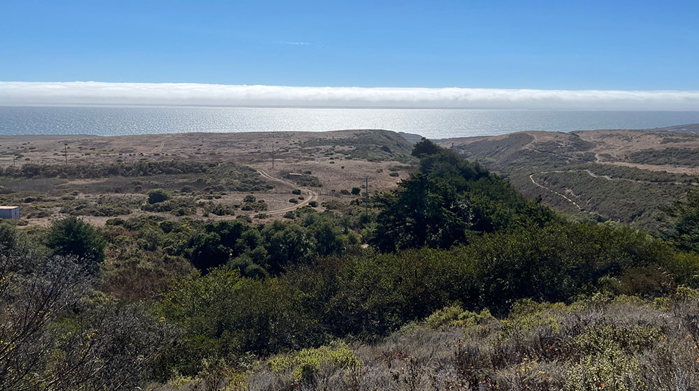
BLM has opened the gate for a walk through time. When you hike the new paths of the Cotoni-Coast Dairies National Monument, the history of the Santa Cruz Mountains and the history of the people who settled here are on display. The sweeping Pacific Ocean views, the three coastal marine terraces, and the lush Mediterranean vegetation unaffected by humans tell the story.
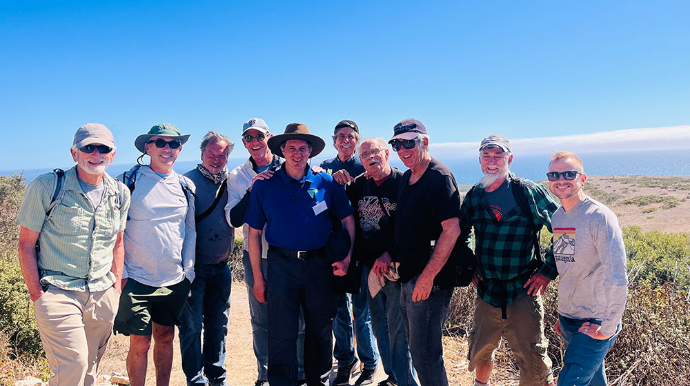
It’s Aug. 15, opening day. I join my gang of nine hiking buddies, along with a hundred others, to walk the first two loops of the new hiking paths. After a million years of Mother Earth lifting these marine terraces to form our coastal mountains, and after 10,000 years of Cotoni stewardship, it took a volunteer workforce eight long, hard years of building the tribe’s legacy into nine miles of hiking trails. Cotoni is pronounced “Cho-toe-knee.”
The parking lot holds 62 cars but the 100 or so hikers have carpooled, and at 3pm we all gather around Ormsby, Central Coast field manager for the Bureau of Land Management, the agency in charge of the site.
As gusts of wind cool us in the afternoon sun, Ormsby speaks of the Cotoni people, a distinct tribe of the Awaswas, also known as the Santa Cruz people. I’m grateful that he explains the monument’s commitment to honoring the Cotoni. The moment sobers our crowd of hikers.
The Cotoni lived here, north of Davenport along the Pacific Ocean, and also on the inland ridge of Ben Lomond Mountain in Bonny Doon. They subsisted on shellfish and edible seeds and leafy greens. They lived in paradise. The Cotoni people were here for over ten thousand years—they really had it made. Then it ended with the arrival of the Spanish. And here we are. It is a small redemption, but we try to remember them.
The Three Loops
Ormsby describes the three loops of trail they have created that are open to the public. The loops are stacked; to get to the final Wildcat Loop, you must pass through the Hawk Loop and then the Tree Loop.
The first loop is Káknu, on the lower marine terrace, and named for the Awaswas word representing hawk. It’s less than three miles round trip and is largely level. It’s a very easy hike with amazing ocean views and it works for hikers, bikers, adaptive accessible bikers and on-leash dogs.
Loop Two is the Tree Loop, with signs that also represent it in the Awaswas language as Tree Trail, or Huyya Trail. This is the loop I take today with most of my hiking buddies. I’ll tell you in a bit how this old body of mine did on Tree, but it’s not hard; the paths are nice and it’s maybe three miles round trip. On-leash dogs and bikes are permitted.
The third path is the Big Path Loop, also named Wildcat. In the Awaswas language, Toróma. This loop is longer, 3.4 miles, steeper, and goes to what Ormsby says is a majestic ridge top terrain. He says, “You’ve got to earn it.” We don’t get to go on the third loop today; there is not enough daylight left to make it back before dark, and sunset is when everyone must leave the park.
Ormsby emphasizes that hikers and bikers really need to stay on the paths. He says off-limit areas include resources that are delicate, and cultural resources that are identified as important to indigenous peoples. Some areas are restricted because of sensitive native plants. He suggests we check out Calflora, a science app that shows all the vegetation communities. And finally, Ormsby tells us about the volunteers who did the 10,000 hours of work to build these nine miles of trails. “They used hand tools and just good old-fashioned hard work. They also raised about $2 million to help fund this.”
Katy Peterson, senior marketing and communications manager of the Santa Cruz Mountains Trail Stewardship, elaborates on the process. “The role of the Santa Cruz Mountains Trail Stewardship in the Cotoni-Coast Dairies National Monument was to lead the design, the funding and the building of the trails. We worked in partnership with the BLM to design the trails. We were involved in the public access meetings held by the BLM and encouraged the community to speak up for what they’d like to see in the property back in 2017, 2018 and 2019. We led the fundraising campaign to raise the $2 million and coordinated the volunteers to build the trails that the public gets to enjoy today.”
questions (photo contributed). Below, the few bikers who passed were all smiles and waves,
which was nice because bikes are here to stay on these multi-use trails. PHOTO: Richard Stockton
Living History
What’s in a name? Many generations, many people.
If you look inside the Cotoni-Coast Dairies National Monument name, the first part refers to the Cotoni people. “Coast” takes you to the property’s extension from the Santa Cruz Mountains to the Pacific Ocean. “Dairies” refers to the property’s history as a century-long dairy farm.
In the 1860s, Swiss farming families acquired the land from Spanish grantees and developed the site into a dairy. The families continued to farm the land for more than a century. In 1998, conservation groups bought the property to prevent private development. About 400 acres were donated to California for a state park and most of the rest was transferred to the BLM in 2014.
At the end of his presidency in 2017, Barack Obama designated Cotoni-Coast Dairies as a unit of the California Coastal National Monument. Before the monument designation, the land faced threats from development, proposed oil drilling and even plans for a nuclear plant. A conservation campaign, led by groups like the Trust for Public Land and Save the Redwoods League, raised $45 million to preserve it. The Trust transferred the land to the Bureau of Land Management in 2014, paving the way for permanent protection and eventual public access.
Where loops one and two connect, the gang of nine surrounds field engineer Mike Powers. “So, Mike, what’s going to keep oil companies from just buying off the feds and come in here and start drilling?”
“There is no oil under this ground.”
That is true enough. Our geologist in residence, Dwight Harbaugh, tells me that Texaco sank a test well on the coastal terrace here in 1956 and did not find enough to go forward. The Cotoni-Coast is safe, at least from capitalism.
When I rode with Dwight up Highway One that morning, he showed me the stark outline of the marine terraces that the whole Central Coast, from mountains to the sea, is made of. The 5,843-acre Cotoni-Coast Dairies property extends over two marine terraces, which may factor into the dramatic wind changes when you walk the trails.
Highway One is on the terrace that falls off to the west, forming the cliffs above the rocks where the Pacific waves crash. The terrace to the east above us starts at the foothills of the Santa Cruz Mountains. Dwight tells me these terraces are formed by the uplift from the Pacific tectonic plate and the North American plate, as they slide horizontally past each other, known as a strike-slip movement. When the rough edges of the plates get stuck, the release of pressure can surface as an earthquake along the fault.
As we switch back and forth through the redwoods, the blackened bark on the redwoods from the CZU fire of 2020 lends weight to the idea of allowing cattle to graze and keep the fire fuel down. The real good news is redwood bark is fire resistant, and most trees live. Rampant fire happened here just five years ago, and Cotoni-Coast looks fine.
The Loop Two trail is a marvel of well-engineered switchbacks, and there were only a few hills where my well-cured body huffed and puffed.
Hikers know that the trick to longevity is to not fall. BLM Field Manager Ormsby said the third loop is more difficult, so I make a note to bring my staff when we return to go to the top. Trekking poles would be excellent.
Organic Weed Eaters
As we walk back to the trailhead, we see big, Black Angus cows, and I must say, thank God for the g in Angus. Mature males can weigh 2,400 pounds, even more. So, why does BLM lease this land to beef growers? It turns out the cows are being used as a land-management tool. Nobody wants pesticides and herbicides in the park, and grazing knocks down fine fuels, like dry grass and thatch, so fires are less intense and spread more slowly. They can also graze on non-native plants that are going to seed. The BLM plan for Cotoni-Coast Dairies explicitly authorizes using livestock to “reduce fine fuel loads and wildfire risk.”
To control these shiny-black behemoths, BLM equips them with solar-powered collars that uses a GPS system. The cows are trained to follow the collar’s beeps and buzzes, which move them in the direction the rancher wants them to go. This “virtual fencing” keeps cows off trails and sensitive sites while still hitting fuel and weed targets.
Ormsby says the digital collars can precisely move the cows to where the non-native plants are going to seed. The rancher who owns the cows moves them with his phone. Ormsby laughs, “He says for the first time in his ranching history he knows where all his cows are.”
Hiking, Biking and Strolling
BLM has a mandate for multi-use of the property and bikes are allowed on the trails. The plan is to make the monument accessible to a wider audience, and this includes adaptive biking paths, such as the Hawk Trail, designed to accommodate hand cycles and other mobility-adapted bikes. There are plans to connect to trail networks, such as the Santa Cruz Coastal Rail Trail. Mountain bikes, including Class 1 e-bikes, are allowed on all trails. With BLM permits, you can also ride horses in some areas.
Hours and parking: The trailhead for Loop One has a parking lot with 62-plus spaces, clean restrooms and picnic tables. Trails are open from sunrise to sunset, and the park is accessible via Cement Plant Road off Highway 1, north of Davenport.
Other rules: Camping, off-trail access and fires are not allowed. Dogs are allowed only on Hawk and Tree trails (Loops 1 & 2) and must be leashed.
How to get there: Drive six miles north from the west side of Santa Cruz on Highway One, past the town of Davenport and turn right onto Cement Plant Road. You’ll pass massive eucalyptus trees that have trunks blackened from a fire on Aug. 13, before Cotoni-Coast Dairies opened. From the lowland eucalyptus to the mountain redwoods, you’ll see blackened bark throughout your hike. Cement Plant Road switches back up into the lower grasslands to the monument entrance.
*Editor’s note: Changes made to this story on Sept. 4, 2025, to provide additional information about the trail construction and the fire that scorched eucalyptus trees.


Thanks for the great and expansive info, Richard
Dogs and Bike options are covered in your article!
I was there opening weekend and did all three loops! Beautiful scenery that changed often, I loved it-My favorite was the Wildcat Loop-which was a little steep and rocky in some parts, but that’s what made it fun! Definitely will return.
As a senior, I’m surprised that bikes and e-bikes are allowed. They’re hard on the land but most importantly, they’re dangerous for hikers. All it takes is a group of fast bikes to knock someone down.
This will discourage many people from using the trails, or was that the idea?
It is my first visit here, and I must say, I am quite impressed to find everything in one location …